Sunday, August 21, 2011

Extra pic of Surprise Lake

Surprise Lake in Teton National Park
I am glad this picture of Surprise Lake in Teton NP popped up in my last roll of film because it is a useful guide for describing the epicness of the vista.  We had just hiked five miles up to the thing with the last half mile being through the snow.  The saddle in the snow is actually a snow bridge over a waterfall that is the birth of a stream down the mountainside.  It drops into a canyon that opens out into Jackson Hole.  You can stand directly over the shiny white water as it spills out of the frozen-over, glacially-deposited lake.  You can also climb out on fallen trees and rock ledges to look directly over the water as well.  Not only is the beauty of the scene is too intricate to corral with words, this was also one of those sights that could barely be enveloped by the frame of a slide of film.  This sight could never be reached by a car.

Tuesday, August 16, 2011

Teton National Park

Janet and Sophia at an overlook from Jackson Hole.

Sunset on the Tetons

We strolled into Teton National Park from Yellowstone on our way back towards Logan.  We were greeted by this vista as we blasted "Blame it on the Tetons" by Modest Mouse for no apparent reason.  We came in Sunday night, stayed at a campsite on Jackson Lake.  We got up early to see the sunrise.  We found this view and similarly stunning views of the mountains as those of the night before, but with a near-mirror-like glass over Jackson lake.

Early morning twilight on Jackson Lake.

The view of Jackson Hole from the slopes of the Teton front.  That oblong mound in the background is a glacial moraine: rocks and rubble transported in a glacier only to be deposited en masse as the ice recedes.  At one point, this glacially carved landscape was covered in ice up to all but the tallest peaks of the Tetons.
We left early Monday morning before the rangers showed up.  This is a great way to save money if you don't care about supporting the maintenance of our beautiful, cash-strapped national parks.  We decided to do a day hike up to Surprise and Amphitheater Lakes.  To Amphitheater Lake it is about 5 miles from the 6,000 ft valley floor up to the 9,700 ft lake.  There were 17 switchbacks.  The Tetons are sheer.  We were greeted as the first ones out on the trail to a black bear at the trailhead.  He went along on his way and we on ours.  Luckily the huckleberries along the trail were not ripe yet or we probably would have seen more than just one busy black bear.  We climbed most of the way with two climbers setting out to conquer all 13,775 ft of Grand Teton.  Any later in the season and the peaks start creating their own afternoon thunderstorms--a vicious obstacle for such exposed rock faces.  The trail up to Surprise Lake is one of those incredible trails that is doggedly tough but totally worthwhile and rewarding at the end.  Both Amphitheater and Surprise Lake are outstanding alpine lakes.  They expressed impossible shades of blue: from black hole dark on to radioactive-bright antifreeze.  Both lakes were still covered in ice and surrounded by spring snow.  The views out onto the valley were too big to photograph and the tobogganing was in season.  A capstone hike to a mammoth weekend.  Actually, deep-dish pizza in Montpelier, Idaho (the site of a Butch Cassidy where the sheriff gave chase on bicycle into the mountains.  They were never caught.  The bank is still open.) followed by Harry Potter on opening weekend was pretty great.  "Come on Harry, let's take a walk."
Surprise Lake, nearly 9,700 feet up in the Teton Range.
PS if you make it up to the Tetons and Yellowstone, you have to try Huckleberry ice cream.  A flavor not to be forgotten.

PPS "Hey, what should we do for the epilogue?"  "How about we let Ron and Harry grow a couple days of stubble and we put Hermione's hair up?"  "OK. that should work." = Harry Potter easy button.

Monday, August 15, 2011

Yellowstone National Park

Mitch in full mullet soon after entering the park.
On a three day weekend, Mitch, Janet, Sophia and I decided to road trip Yellowstone and Teton National Parks.  We left about an hour after getting back for the weekend and stayed friday night in Bridger National Forest in Wyoming, near Alpine.  After driving through Jackson Hole and past the Tetons we entered the park and headed straight for Old Faithful.
Old Faithful erupted in minutes after we walked up.  I've never seen a dog so politely excited and so thoroughly ignored.  It was the only dog around a thousand people and no one cared.
She blew about two minutes after we arrived.  Feeling up on our luck, we pranced around deriding all the other tourists.  Many instantly dispersed back to their lodges and RVs after Old Faithful erupted.  Others stayed to peruse around to other geysers.  They had saved up their life's earnings to get an RV with which to visit all the great highway-accessible sights of the continent.  Yellowstone is built for that tourist and that tourist was getting his money's worth on this day.  Still others were awkward adolescents and showed up with their parents for Roadtrip Cringefest 2011.  Our favorites were the few who possessed an unquenchable sense of wonder.  Overheard on the matter of the steam coming out of hot springs: "Does the heat make it rise?" "Yep." "Ooh."  A close second were those tourists with checklists, who would cruise right past hot springs like the one below without even a glance as they rushed on to their next destination.  I like to think these tourists needed to use the restroom.  I mean who is legitimately blasĂ© about forbidden hot springs?!?  Not even a glance??!?  We hiked the half mile out to Solitary Geyser (which is so ridiculous and appropriate for Yellowstone) and saw it practically blow us off the mountain.  We waited the 5-8 minutes for another in order to take a picture, but it just so turns out that the first eruption was the biggest in the last 15 years and the lil' bubbler for which we waited was grossly underwhelming.
Superheated sulfurous death, but still tempting.
After Old Faithful we drove on through to the Madison campground.  As expected it was packed, but after dinner we walked to the Purple Mountain Trail.  It was evening and it was dark for most of our descent back down the 8,433ft hill.  We did not see a single person on the trail, which, given our location as a haven for cougars, grizzlies, wolves, moose, etc, was as troubling as it was refreshing.  Yellowstone is advertised as and feels like a safari through a time portal into a fictitious version of North America in 2,000 BC.  It is primal and manufactured at the same time.  Still, it is incredible to get on a trail, be alone, and see the prodigious growth amid the still apparent wreckage of the Fires of 1988.  The place almost feels like the heart of the continent given its location on the continental divide, its geothermal activity and its high altitude for a flat area. The mosaic of young lodgepole forest and soft meadows adds to the feel of a newly forming territory entirely distinct from the nearby Tetons.

Yellowstone from the slopes of Purple Mountain.  Washed out in afternoon sun, but all the standing dead from the fires of 1988 are still visible amid the regrowth.
The album cover for Mitchell Fosnaugh: The Album.  A lazy sunday afternoon on our way back to Teton National Park.
We often lunched at picnic areas.  The Sunday picnic area bordered a huge grassy field that was great for relaxing, digesting, and listening to music.  Mitch has taken to calling his guitar a shirt, as this seems to help him get around those "no shirt, no shoes, no service" regulations.

Ensign Peak and the City of Salt Lake


Sloppy Sophia looking like the real deal while cutting tread for a trail.

We got a taste of trailwork before we again succumbed to the curse of the SLC City Council.  The project fell apart and we got banished to a third week in the dog park.  Oh well, I got a view of Salt Lake City from above.  Mormon pioneers who came from the East (left on the picture below) at what is now This is the Place State Park climbed Ensign Peak to survey the headquarters of the empire that they would create in this newfound region that they called Zion.
The City of Salt Lake from the peak where it was planned.
The Wasatch front along the Salt Lake City metro area

While in and around Salt Lake for the week, I had a chance to spend an hour downtown.  I walked through Temple Square on my way to the Family History Museum.  I found two of the vaunted sister missionaries (many girls who do missions get sent to Salt Lake to be present around the LDS headquarters.  Interestingly, young men generally do not, as far as I know, get sent to Salt Lake.  That, to me, is indicative of some bizarre gender norms, or worse.  But that is the Church's trip, not mine.)  I wanted to forever remember SLC bizarro, so I asked my two new friends, one from Malaysia and one from Singapore to take a picture with me.  Being obligate helpful souls, I gave a third an opportunity to help me out by clicking the shutter.

Two sister missionaries, Sophia and I in Temple Square.  They are obligated to be happy and nice.  It is their mission.
In the Family History Museum I found that my great great great great grandfather William Coe Critchlow moved his wife Harriett and children William Fuller, Benjamin Chamberlain and Scharlot out west to the Ogden/Brigham City area north of Salt Lake in the 1850s to farm.  They were Mormons from Pennsylvania.  William Fuller married Mary Eliza who gave birth to William J in 1868.  William J would meet a very special Anna C (she was Danish) who would give birth to my great grandfather Victor David Critchlow in Ogden in that fateful November of 1898.  Victor David's brother, William J Jr. would go on to become a high priest, stake president and general authority within the Church of Latter Day Saints.  Victor David divorced my great grandmother Jesse and was largely absent from the lives of the subsequent line of the Critchlow clan except for one occasion when he showed up to a family barbecue and happened to drop dead in the backyard, or at least that's how my own father describes the imprint on his ten-year-old brain.

In any case, I am not Mormon, and after that tragic exit and dramatic encore in the lives of us non-LDS Critchlows, I will remain dubious towards a comeback by the Mormon church in my family.  As far as I know, there are still Mormon Critchlows in the Ogden area.

The City of Rocks and User-created "Social" Trails

AngĂ©lica and Boris, two friendly locals who introduced themselves to Janet and I.  The other locals were too shy to introduce themselves.
The City of Rocks is a valley full of granite boulders in Southern Idaho.  To get there from Logan, you head west out of Cache Valley through Riverside and then onto I-84 in Tremonton.  You then cross into Idaho through some windy antelope country.  After exiting at Malta you cut through Elba and Almo to the "city." It is far away, and it is beautiful.  Most people would describe the encompassing Raft River Valley as a barren and exposed valley of sagebrush dissected by lonely roads that connect dreary towns that are colloquially referred to as "rusting piles of farming equipment."  The pioneers on the Oregon Trail called the place "paradise" because there was a river and some grass for their teams in the sagebrush.

Part of the reason The City of Rocks is designated a National Reserve by the Park Service is the cultural history of the area.  There was a main intersection of routes of the California and Oregon Trails in the Raft River Valley.  Misspelled frontier names scrawled in charcoal with dates like '72 or '63 are still faintly visible on the slowly aging granite boulders that line the old trails.  In some places, tire ruts are still visible.  That fact is a powerful one to me.  The trail of the California Trail was made by traffic--just the same as any unofficial, user-created "social" trail.  Wheels and footsteps compact the ground and squeeze out any air in the soil, rendering the ground sterile.  Vegetation stops growing.  The compacting process lowers the trail relative to the ground on either side.  Depending on the topography this lowered ground can short-circuit water drainage in the area.  The trail becomes a seasonal stream.  Water-caused erosion occurs and the trail becomes permanent.  After 150 years, the tire ruts are still visible pretty much only where water drainage occurs.  The lesson is to stay on the trail and leave the social trails alone.  If you don't, your tracks could be there for decades (if they don't lead to washouts and promote total erosion) as all those footsteps squash the vitality out of the soil.  If on a trail on a hillside and the social trail cuts a more direct route through switchbacks, then it creates a slide for water to wash away the whole trail right down the slope.  If you like the trail, stay on it.
The skyline of the "city"
The City of Rocks is a result of the weathering of granite.  Granite is tough, and the initial weathering just adjusts the top layer to form a protective cap that over the granite lying underneath.  Then the whole column weathers even slower.  The surrounding rocks erode away leaving natural granite spires jutting from the ground.   Today, rock climbers drawn to the intricate granite formations make up nearly all of the visitors to the "city."  I would wager (a lot of money) that The City of Rocks has more climbable granite faces than permanent residents.  As an aside, amateur rock climbers are amusing to watch as they slowly pull themselves up an otherwise unremarkable granite face, relaying announcements of intentions from the climber to the various safety personnel at the top and bottom.   The effort and difficulty doesn't show itself to the spectator very readily and it seems an unrewarding and overly complicated endeavor at first glance.
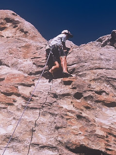
Two mediocre pictures of a climber in City of the Rocks.  I promised his wife I would email the pics after standing under her husband looking up through a zoom lens.  But I misplaced the email address, so if anyone knows it, or knows where I put it, please let me know.  Here's to hoping that he reads my blog.
Field of wild iris between Sawtooth National Forest and City of the Rocks
From The City of Rocks we went up into the hills around the "city" to camp.  The hills are part of the Sawtooth National Forest.  We had incredible views both as the sun set and again when it rose of the valleys on either side.  Marmot and mule deer frequently crossed our paths.
The view from the Sawtooth forest out over Idaho in the late afternoon.  The haze added to the dreamscape feel after a long day.
On Sunday morning we made our way down the dirt roads back towards Burley and around on to Logan.  We took the long road because we were low on gas and Burley is the closest gas out there.  However dirt roads are more like rock roads on top of hills, and rock roads in The City of Rocks are made of granite.  As we rolled down in neutral we noticed we had gotten a flat.  The tire had ripped an unrepairable hole, because her tires were bald and we were driving down a granite road in a minivan.  We pulled out the compact spare and changed the tire, still about ten miles of dirt road from pavement and then another 15 miles from gas.  Several people drove by us, and most of them slowed, although only to make sure that we had indeed suffered a flat tire.  One person even stopped, although only to ask us to move more into the ditch at the side of the road.  The amusing part of the story is that this occurred on Sunday morning.. on July 3rd.. in Southern Idaho, which is better described by the term "Mormon Country."  Luckily, Wal-Mart's global conquest is nearly complete and we were able to find a tire.  For various reasons, Janet could not tell her parents the whole story, so they would not agree to buy a whole set and so Janet maintained the lie and only purchased one tire.  She has since gotten her parents to pay for a full set, so now in the back of her clean-shoed home she has a compact spare and a brand-new full-size tire.  The buffalo is built to roam.
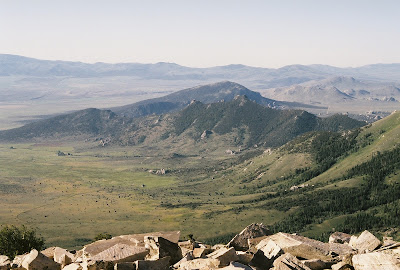
The view down on The City of Rocks the morning of Sunday, July 3.

To Tony Grove we go!

A nice little trail into the Mt. Naomi Wilderness area
Over the river and through the woods... is the way to most everywhere in the Bear River Range.  Back on Saturday, June 25, Janet and I embarked on the Jardine Juniper trail planning to take the Cottonwood Canyon trail into the Mt. Naomi Wilderness Area. The Jardine Juniper trail is a five mile trail up to an 1500 year old Juniper tree.  I signed the visitor book at the tree, ate lunch, and took a picture of a similarly grizzled and charred old battle-ax of a tree because it was more photogenic.  This is a story of two young fools who wandered into the wilderness in search of adventure.

Junipers grow slow, and they get to be inconceivably old
The horse knows the way to carry the sleigh... We went over the ridge into the wilderness area and quickly entered a new environment: no more horses or mountain bikers--there was hardly any more path at all.  No one had been in to maintenance the trail and remove the fallen trunks from the fire that blazed through the canyon last year.  Still disgruntled about walking around the Dog Park all week, we salivated at the thought of hiking five miles up to the start of wilderness area with axe in hand (no power tools in a wilderness area) with the job of chopping all the fallens and widowmakers away from the trail all the way through to Tony Grove.  Around 3pm we made it down to the South Fork of the Cottonwood Creek--which was swollen, splashing and fast with snowmelt--and decided that instead of camping here in solitude near the willows we would cross the creek and try to go through the wilderness area to Tony Grove.  If we were true tragic heros, this would have been the decision of tell-tale hubris.  On we went, map in hand, having forgot a compass and water purification.  We ambled up canyon floor,  a breathtaking mile through aspen grove, meadow, and willow-thicketed and boulder-strewn creekbed.  We came upon barn owls silently swooping through the tree tops.  Ever vigilant for moose we eventually reached the head of the canyon.  By that point the trail was invisible under a foot of snow.  We were lost.

The view down Cottonwood Canyon.  From the side close to the trailhead.
Through the white and drifted snow... approached a dark brown, medium sized animal down the valley slope just after the sun dropped below the silhouette of Mt. Elmer with a seemingly aggressive, hunched and lurky gait.  WOLVERINE I assumed.  We quickly retreated and scampered up the opposite slope.  We watched it from partway up the slope to see if it is fulfilling its obligation as part of the wolverine script.  In my imagined worst-case scenario, it is supposed to track our scent and footsteps towards us, across the creek and up the slope to the lara bars and peanut butter in my backpack.  It did not fulfill its obligation and we continued ascending in the hope of shortcutting the trail up the ridgetop as we were too preoccupied with that ominous mystery-animal down by the creek to follow the assumed path of the snow-covered trail.  On our way up we saw another similar animal, but at a much closer distance.  A porcupine, and if not for the fact that I was running low on water and we were still lost and as we climbed the snow only got deeper.  Porcupines are funny nocturnal animals.  They are very slow, and they compliment their near-slothlike slowness with a remarkable lack of coordination.   We stumbled upon a third animal on the ridge and stopped to watch it flee us up into a tree.  After several minutes and the porcupine still only at hip level, both Janet and I wondered whether it still was trying to escape or if it had changed its plans at the first limb.

We seem to go extremely slow...  We make the ridgeline, 800 feet above the creek and over 8,000 feet in elevation (although we didn't know that at the time), set down our packs and explore farther up hoping to see hope that we can make it through to Tony Grove.  We move slower and slower, we stumble, and short distances seem to stretch on endlessly.  We are both dehydrated and fatigued and after seeing little but unidentified slopes and snow, we decide to pitch our tents and hike back the 8 miles in the morning to the Jardine Juniper trailhead and hope we have enough water.

The ridgeline opposite the one we climbed, see from down the canyon.  The peak is Mt. Elmer and to the left is Mt. Jardine, both above 9,500 feet.
Over the river and through the wood–
Now Grandmother's cap I spy!
Hurrah for the fun! Is the pudding done?
Hurrah for the pumpkin pie!

After hiking out surprisingly fast in the morning, we came back to Logan with one goal in mind: a $2.79 Ben and Jerry's pint.